Survey scanning and performance
Contents
The observation strategy[edit]
The Planck observation strategy, or scanning strategy, makes use of the characteristics of the Planck spacecraft and orbit in order to achieve the survey goals in terms of sky coverage and scanning directions.
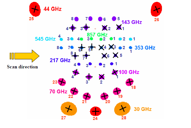
The scanning direction of the Planck focal plane is explained in the figure below.
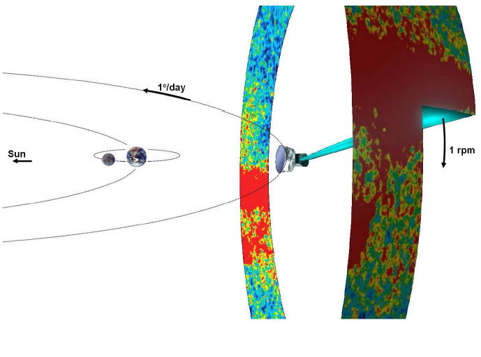
The Planck spacecraft spins at a rate of 1 rpm, and the angle between the nominal optical axis and the spin axis is 85 degrees. The path followed by the Planck spin axis is defined with respect to the Ecliptic plane. It corresponds to a motion in longitude which maintains an anti-Sun pointing, to which is added a cycloidal motion (precession) of the spin axis around the anti-Sun position (fiducial point). The cycloidal path is defined by the following functions:
- λ = θ sin((-1)n ω(t-t0) + φ) (eq. 1)
- β = -θ cos((-1)n ω(t-t0) + φ) (eq. 2)
where λ is the angular distance from the fiducial point in Ecliptic longitude, β the angular distance from the fiducial point in Ecliptic latitude, θ the spin axis precession amplitude, ω the pulsation of the precession, φ its phase, n the parameter which controls the motion direction of the precession, t is the time, and t0 is the first time during the Planck survey at which the fiducial point crosses the 0 Ecliptic longitude line.
The reasons to decide to use such a precession of the spin axis are mainly that (see PL-WG9-TN-001 for a more detailed explanation):
- An excursion of the spin axis from the anti-Sun direction is required to fully observe the whole sky (no excursion would leave a large area unobserved around the Ecliptic poles)
- The precession motion allows to keep the Sun aspect angle constant during the whole survey, therefore minimizing the thermal constraint variations on the spacecraft
The following precession parameters have been chosen for the BSS:
- amplitude θ = 7.5o (this value is the lowest possible which allows to cover the whole sky with all detectors)
- n = 1 (anti-clockwise motion as seen from the Sun)
- pulsation ω = 2π / (half a year)
- The phase of the precession will be decided according to this set of criteria (in order of importance):
- respecting the operational constraints - allowing the largest possible angle between two scans on the Crab - avoiding null dipole amplitude for the whole mission - optimizing the position of the planets in the beginning of the survey and with respect to the feasibility of their recovery (*) - placing the two “deep fields” where Galactic foregrounds are minimum - allowing a reasonable survey margin
The details of the justifications for these parameters can be found in PL-WG9-TN-001.
The phase is 340 deg. for Surveys 1 to 4, and 250 deg. for Surveys 5 to 8.
The scanning strategy parameters are input to the PSO Survey Planning and Performance Tool, which is the software which generates the series of pointings transmitted to MOC for implementation of the BSS.
Launch date and start of Survey Operations[edit]
The definition of the BSS is mostly independent of the launch date and the start date of survey operations. However, since the definition of the Planck orbit around L2 depends on the launch date, this can affect the choice of a few parameters of the scanning strategy. Indeed, not all precession phases are allowed for all launch dates (see below). Once the launch date is known, the start date of the survey operations does not influence the scanning strategy parameters.
Spin axis manoeuvres and exact pointings[edit]
The motion of the spin axis is not continuous. Every change in the spin axis position will be initiated by a manoeuvre which requires less than 5 minutes of time to be completed.
The duration between spin-axis manoeuvres is hereafter referred to as “dwell times”; and the angular distance between manoeuvres along the spin axis path is hereafter referred to as “spacings”.
The dwell times and spacings for the BSS are defined as follows: • The spacings are fixed to 2’. This is a parameter entered into the Survey Planning & Performance Tool. • The dwell times vary from 2360 s to 3904 s. The exact coordinates and dwell times are set by equations 1 and 2 when one has fixed the spacings.
Special observations[edit]
The special observations which can be foreseen in advance and integrated in the long-term pointing plan are listed in the Science Operations Plan for the Routine Phase:
- special scanning on Solar System objects for calibration purposes
This will concern the following objects (planets): Mars, Jupiter, Saturn, Uranus and Neptune. The Baseline Scanning Strategy will be maintained, but a special case will be set for Small-Gap Recovery algorithm application (see Planck/PSO/2005-016).
- special scanning on other (non-moving) sources (Galactic plane, etc) for calibration purposes
This will concern mostly the Crab Nebula for polarization calibration purposes. Two scans with scanning angles separated by at least 12 degrees will be performed. This will be achieved by adequately choosing the initial precession phase.
- special pointings during the calibration phase, not relative to celestial sources
(*) The 1-N thrusters problems make it more difficult to recover gaps, since the 20-N thrusters must now be used to initiate a recovery. During roughly half of the year (in two 3-month periods), the recovery is not feasible because the margin with respect to the celestial constraints is too small. Therefore, we try to optimize the cycloid phase in order to have the most important planets in a recoverable area.
The survey requirements and survey goals[edit]
The survey requirements are numbers which are required to be achieved at the end of the Planck nominal mission. They correspond to the values obtained from 12 months of observation, with the sensitivity which is measured in-flight during CPV phase. The survey requirements are the following:
- mean integration time over the sky, in seconds / square degree
- percentile of sky not observed
- percentile of sky below half mean integration time
- percentile of sky above four times mean integration time
- percentile of sky above nine times mean integration time (i.e. “deep fields”)
- percentile of sky in which coverage suffers from sharp gradients (> 500 in grad(sec/deg2) )
- percentile of sky in which scanning directions are at least 5 over 16
See Planck/PSO/2006-009 section 4.2.2 for more details on these quantities.
Meaning of these requirements: - mean: the integration time averaged over the sky at the end of the mission should be at least the one mentioned in the table, for each row / frequency - the precentile of sky not observed should be zero - (no strong requirement from the three central columns) - the precentile of sky suffering from sharp gradients should be at most the value indicated in the table, for each row / frequency (TBC) - the percentile of the sky for which scanning directions probed are at least 5 over 16 should be at least the value indicated in the table
Survey goals are numbers which are wished to be achieved at the end of the Planck nominal mission. Survey goals correspond to the values obtained after a complete nominal mission (15 months of survey with nominal noise – as predicted from ground, and no gaps). The survey goals are the same quantities as the survey requirements. The tables below present these quantities the same way as for the survey requirements.
Start and end of surveys[edit]
The completion of a given “survey” is declared when the logical AND of all frequency-coverage maps is greater than 95 %, OR the sky has been surveyed over a consecutive period of 7.5 months.
In practice, since the gaps during the surveys have always been very small, it results in ~ six months per survey.
- Survey 1: starts August 13, 2009, ends Feb. 10, 2010
- Survey 2: starts Feb. 10, 2010, ends Aug. 14, 2010
- Survey 3: starts Aug. 14, 2010, ends Feb. 12, 2011
- Survey 4: starts Feb. 12, 2011, ends July 30th, 2011
This survey was shortened in ordered to start earlier with the new scanning strategy (see above)
- Survey 5:
Planets and calibrators during surveys[edit]
- Crab: Sept. 16, 2009 – Sept. 22, 2009
- Mars: Oct. 17, 2009 – Oct. 29, 2009
- Jupiter: Oct. 25, 2009 – Nov. 1, 2009
- Neptune: Nov. 1, 2009 – Nov. 8, 2009
- Uranus: Dec. 6, 2009 – Dec. 16, 2009
- Saturn: Jan. 2, 2010 – Jan. 8, 2010
- Crab: March 6, 2010 – March 12, 2010
- Mars: April 9, 2010 – April 18, 2010
- Neptune: May 15, 2010 – May 23, 2010
- Saturn: June 13, 2010 – June 22, 2010
- Uranus: June 27, 2010 – July 5, 2010
- Jupiter: July 1, 2010 – July 9, 2010
- Crab: Sept. 15, 2010 – Sept. 21, 2010
- Neptune: Nov. 3, 2010 – Nov. 11, 2010
- Jupiter: Dec. 9, 2010 – Dec. 18, 2010
- Uranus: Dec. 12, 2010 – Dec. 21, 2010
- Saturn: Jan. 15, 2011 – Jan. 22, 2011
- Crab: March 7, 2011 – March 12, 2011
- Neptune: May 18, 2011 – May 26, 2011
- Saturn: June 30, 2011 – July 9, 2011
- Uranus: July 3, 2011 – July 11, 2011
- Jupiter: Aug. 9, 2011 – Aug. 15, 2011
revolutions per minute
Planck Science Office
[ESA's] Mission Operation Center [Darmstadt, Germany]
Calibration and Performance Verification
To be confirmed

